
Jonathan Smith runs Where2walk, a walking company in the Yorkshire Dales. Jonathan has written his own book, the Dales 30 which details the highest mountains in the Dales. He also runs one-day navigation courses for beginners and intermediates. Join his Learn a Skill, Climb a Hill weekends in the Dales. To find out more details on any of the above visit his website, where2walk.co.uk
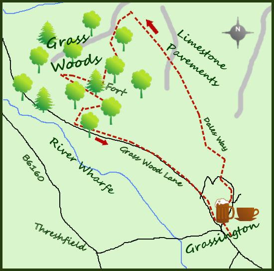
MOST walkers head for the river from Grassington, but a better walk is to head on to the limestone pavements above the village and return via the splendid Grass Woods.
Grassington is a popular village, but this walk will take you away from the crowds. From the national park car park head through the centre of the village and up the hill past the Forresters Arms. Approaching the top of the town, turn left along a road for 250 meters to a signpost on your right for the Dales Way. Head up the lane for a further 200 m to a stile on your left. The path now fiddles its way across four fields/three stiles along a faint path to emerge on to open countryside and a more obvious track. You have been following the Dales Way, an 80-mile long-distance footpath from Ilkley to the shores of Windermere in the Lake District.
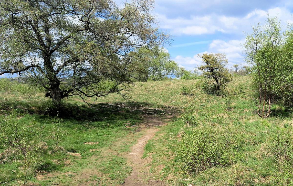
On arriving on the open hillside, leave the main track to your left and as long as you keep the wall to your left you can pick your own route. This is access land with a right to roam away from the path so take your time and enjoy picking your way through the lovely limestone pavements. The route climbs gradually and starts to fall for over half a mile. The bare rock is interspersed with easy walking on short grass until you meet a more obvious track heading to a gate in the wall on your left.
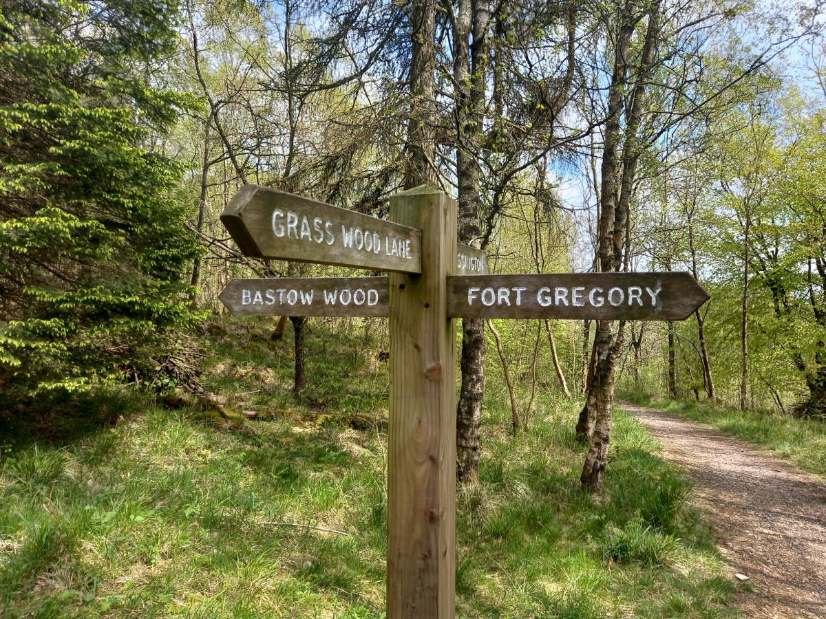
After passing through the gate, a path winds its way through some sparse woodland, marking the start of Grass Woods. The Grass Woods are lovely, particularly at this time of year when the predominantly ash trees are complemented by wonderful wild flowers and the sound of bird song. After a stile the path soon meets a major track and a route decision needs to be made. The signpost points to Fort Gregory (an old Brigantes Fort) which is best to follow. After the remains of the fort the path turns initially right and starts to zig-zag down the hillside. The paths are good and the walking is easy. Before the long the path meets a dry stone wall and bends right which leads to a gate and the exit from the woods.
After passing through the gate turn left on to a quiet road. This will lead back all the way to Grassington, one mile away. There are glimpses of the River Wharfe to your right and also one of the most attractive setting for a cricket ground in the country.
Grassington has recently been the setting for the filming of the second series of the new James Herriot TV programme, pop in to the café and the Stripey Badger bookshop at the top of the market square to find out more.
Fact box:
Distance: Roughly 5 miles
Height to climb: 160m (520 feet).
Start: SE 004636. Park in the national park car park and walk along the main road in to the central square of Grassington.
Difficulty: Easy: Some navigational challenges in the woods but even if you get lost, it will only be temporary.
Refreshments: Plenty of cafes and pubs to choose from in Grassington.
Be Prepared: The route description and sketch map only provide a guide to the walk. You must take out and be able to read a map (O/S Explorer OL2) and in cloudy/misty conditions a compass (essential on this walk). You must also wear the correct clothing and footwear for the outdoors. Whilst every effort is made to provide accurate information, walkers head out at their own risk. Please observe the Countryside Code and park sensibly.


Comments: Our rules
We want our comments to be a lively and valuable part of our community - a place where readers can debate and engage with the most important local issues. The ability to comment on our stories is a privilege, not a right, however, and that privilege may be withdrawn if it is abused or misused.
Please report any comments that break our rules.
Read the rules here