
A SEVEN-MILE walk sandwiched between York and the North York Moors takes in the Howardian Hills that are full of interest and variety.
Three small but immaculate hamlets ring fence a walk along the river and a more airy walk along Cautley Bank.
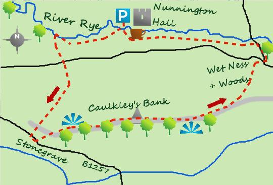
Little more than five miles south of Helmsley lies a National Trust maintained country house in the small village of Nunnington. Period rooms and a picturesque riverside setting are its most pleasant features.
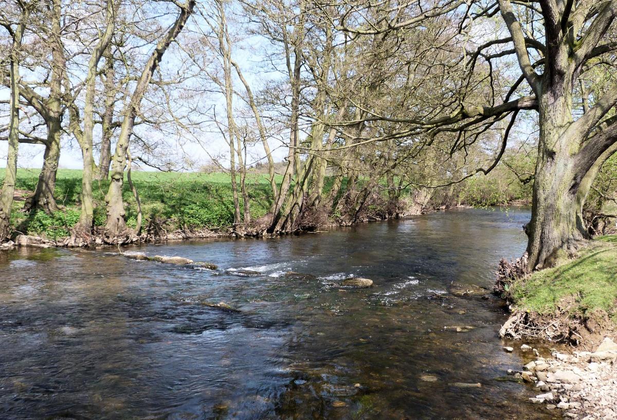
Park in the car park, take the footbridge to the hall and at the main entrance enter Low Road heading west through some attractive Yorkshire Stone buildings. Where the road bends left take the stile directly ahead and join a riverside path. A sign points to High Moor Lane, one mile distant. The River Rye has passed through the uplands of the moors before joining the River Derwent further east.
At two thirds of a distance, the path leaves the river and passes a copse of trees before heading south along High Moor Lane.
The track climbs towards a quiet road, cross the road and a few metres on your left the path carries on through farmland uphill towards a broad ridge. Continue over the high point and follow the track as it descends, initially leisurely but as it starts to bend, more steeply. The final 100 foot drop is much steeper and arrives at a busier road. This is Stonegrave.
Cross the road and enter the hamlet, no more than 100 residents reside here. It will not take long to explore but search out the Stonegrave Minster, a church with origins in the 8th century.
Recross the road and 100 metres to the west of the outbound path a bridlepath heads uphill. It is a lovely wide path flanked by attractive woodland (well, will be in the spring!). On arrival at the high point of Caulkleys Bank the views open out beautifully. To the north the moors are shown to good effect whilst elsewhere the Vale of York and the Howardian Hills add interest to the miles upon miles of scenery.
Walking along the lane on the high point of the bank (there is a trig point and bench at 98m) does not seem to last long enough and soon starts to drop down towards the third hamlet of the day, West Ness.
Enter West Ness and yet again it is worth having a look at the immaculate buildings (East Ness is not far away either). Don’t cross the river but keep to the south bank and join the riverside path.
The path is well signposted, in fact I generally find the paths better signposted on this side of Yorkshire as opposed to the Dales end!
Pass the Old Mill and its nearby weir before leaving the river before arriving back at Nunnington.
There are some good views of the hall before arriving at the village proper.
Fact File:
Distance: Roughly seven miles
Height Climbed: 140m (460 feet)
Start: SE 669796. Park in the NT car park.
Difficulty: Medium. The tracks are excellent and well signposted although the paths by the river can be muddy at this time of the year.
Refreshments: The hall has a café in but sadly the local pub, the Royal Oak, has closed, seemingly permanently.
Be Prepared:
The route description and sketch map only provide a guide to the walk. You must take out and be able to read a map (O/S Explorer 300) and in cloudy/misty conditions a compass (essential on this walk).
You must also wear the correct clothing and footwear for the outdoors. Whilst every effort is made to provide accurate information, walkers head out at their own risk.
Please observe the Countryside Code and park sensibly.


Comments: Our rules
We want our comments to be a lively and valuable part of our community - a place where readers can debate and engage with the most important local issues. The ability to comment on our stories is a privilege, not a right, however, and that privilege may be withdrawn if it is abused or misused.
Please report any comments that break our rules.
Read the rules here