

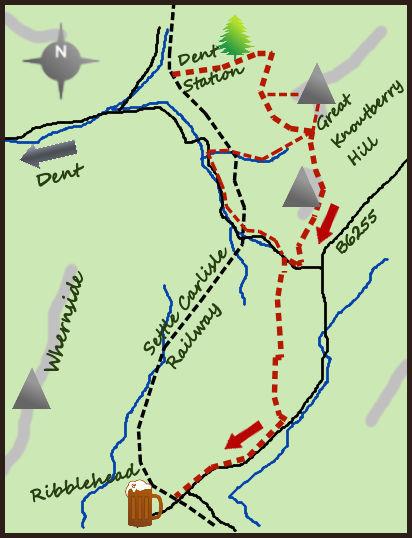
MAKE use of the best section of the Settle Carlisle railway and do a one-day walk between Dent Station and Ribblehead. Visit the highest station in England, pass near three viaducts and some remote walking in Upper Dentdale.
From a practical point I prefer parking at Ribblehead and then taking the train to Dent Station and walk back. It is always advisable on one-way walks to take the transport bit first and in addition there is also a pub at Ribblehead. It is perfectly possible however to do the walk in reverse. At present there is a train at 9.06 and 10.39 (but please check). The journey takes 10 minutes and on arrival at Dent Station you are at the highest station in England. Do not expect to see a village nearby though, Dent itself is four miles away. The station is lovely though. On meeting the moor road turn right and follow it for one mile to a lane on your right with some limited parking.
The wide track contours Great Knoutberry Hill. It starts south and eventually swings east during the two miles leading to an obvious junction of paths (complete with signpost). The path has superb views down Dentdale, a picture perfect dale from this angle. In addition the track passes the remains of coal mines and limestone quarrying. The special hard limestone of the area was used during the 19th century to make marble, a surprising building material that became popular and famous for a while – apparently Queen Victoria had a Dent Marble fireplace. An alternative route to the cross roads is to climb Great Knoutberry Hill, accessed on open hillside just after a wall after the first half mile. It is a 500 feet (160m) climb to the summit of one of the best of the Dales 30 mountains. Return to the cross roads due south from the summit.
From the cross roads to the south of Great Knoutberry take the path turning soon in to a track heading south. After an easy and short climb the path skirts the higher land of Wold Fell to the east and has excellent views down Widdale towards Wensleydale. This is the Pennine Bridleway and soon starts to head downhill towards Newby Head. After one mile of gradual descent the track meets a quiet road (leading in to Upper Dentdale). Turn right along the road for 500m to a signpost to a bridlepath heading south (on your left). The path is reasonably flat but passes over rougher ground and is often wet. After 2/3 of a mile the path passes some grouse butts. After these continue for 1/3 of a mile and when the path splits take the south/right fork (leaving the bridlepath) and carry on a footpath alongside a wall. After a further 2/3 of a mile the path turns left, continuing alongside the wall as it drops down to a farm track at Winshaw Farm and soon to a road. Turn right at the road and follow it for one and a half miles to Ribblehead, leaving time for a visit to the viaduct and the pub!
One alternative (marked on the map) visits both Arten Gill and Dent Head Viaducts. Both of these are superb in their own right but does entail a 250 metre drop (and one and half miles extra) in to the valley of Upper Dentdale. The decision is made at the junction south of Great Knoutberry Hill. At the valley floor (just past Arten Gill viaduct) continue left up the road past Dent Head Viaduct to meet the main route at the bridlepath heading in to the rougher ground. Both options are enjoyable.
Fact box:
Distance: Roughly 9.5 miles
Height to Climb: 350m (1,150 feet)
Start: SD 764875. This marks the start of the walk from Dent Station after taking the train from Ribblehead.
Difficulty: Medium/Hard. The paths are good and they pass through some remote lands.
Refreshments: The Station Inn at Ribblehead marks the start and finish of the walk.
Be Prepared: The route description and sketch map only provide a guide to the walk. You must take out and be able to read a map (O/S Explorer OL2) and in cloudy/misty conditions a compass. You must also wear the correct clothing and footwear for the outdoors. Whilst every effort is made to provide accurate information, walkers head out at their own risk. Please observe the Countryside Code and park sensibly.
* Jonathan Smith runs Where2walk, a walking company in the Yorkshire Dales.
He has written his own book, the Dales 30, which details the highest mountains in the Dales. He also runs one-day navigation courses for beginners and intermediates.
Join his Learn a Skill, Climb a Hill weekends in the Dales.
Visit where2walk.co.uk


Comments: Our rules
We want our comments to be a lively and valuable part of our community - a place where readers can debate and engage with the most important local issues. The ability to comment on our stories is a privilege, not a right, however, and that privilege may be withdrawn if it is abused or misused.
Please report any comments that break our rules.
Read the rules here