
THE walk to Malo Cross is not long but full of interest and variety.
The terrain is a mix of woodland, fields and moors. There are some excellent views from Whinny Hill towards the sea at Whitby at the end of the walk.
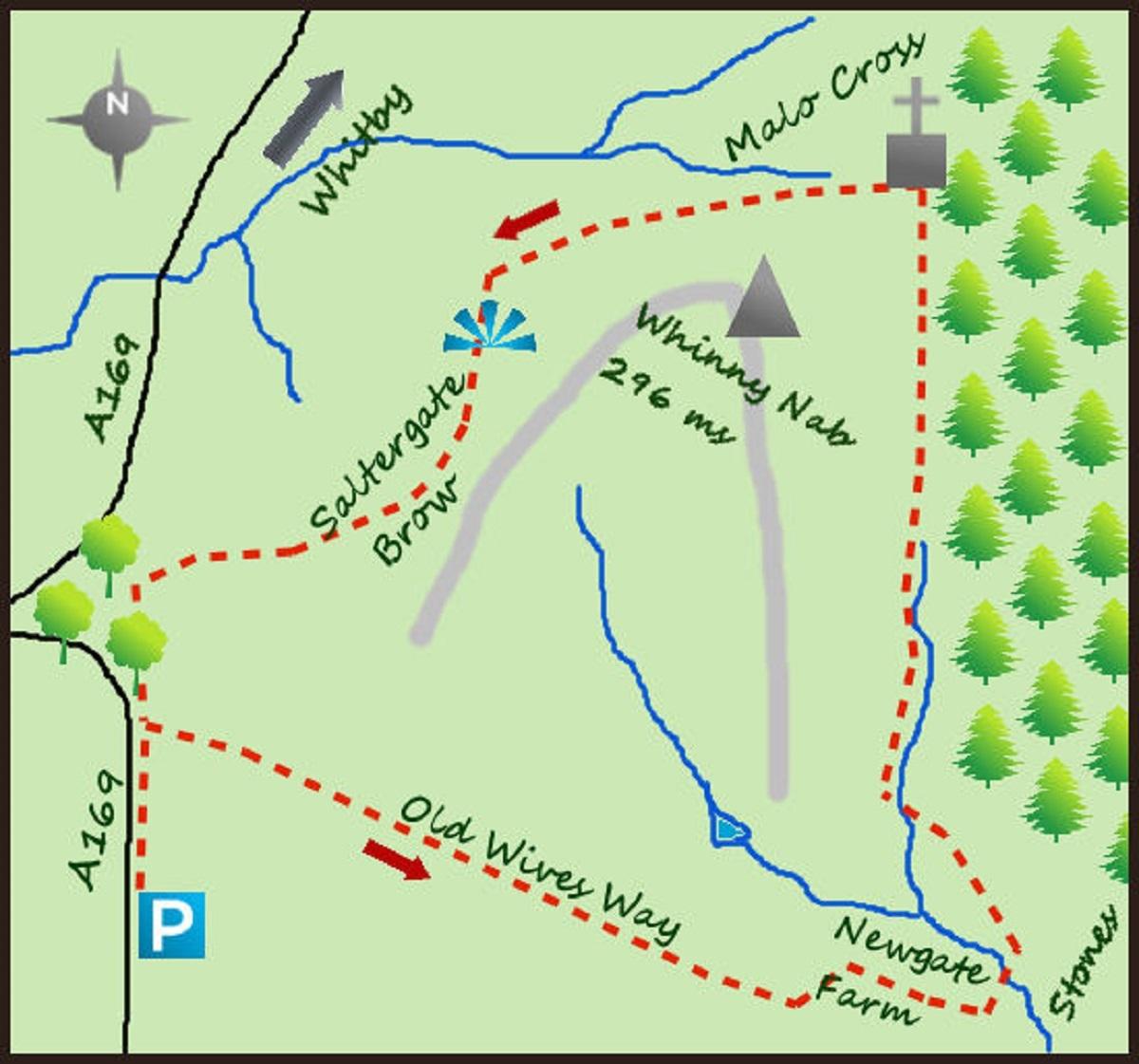
The Saltergate car park on the A169 is normally used by the many who cross the road and head for the Hole of Horcum. If you have not seen it do cross and have a look from above.
However to search for Malo Cross and leave the crowds head north along the road for a few metres but before the road bends there is a lane heading off to the right. This is Old Wife’s Way, possibly named after the ancient lady of legend who oversaw the fertility of the young ladies in ancient times. The lane heads over fields towards some forestry ahead and to the left.
Where the lane meets a second lane coming in from the right turn left and drop steeply towards a farm. This is Newgate Farm at the foot of Newgate Brow. If you continue along the track north east for 200 metres there is one of the three standing stones of Newgate in a field to your left. A smaller one lies nearby and the third is tucked in to the wall.
Return to the farm and take a footpath heading north with the woods on your right. Follow the footpath for one mile, the path is sandwiched between Langdale Forest and some high, steep land to the left.
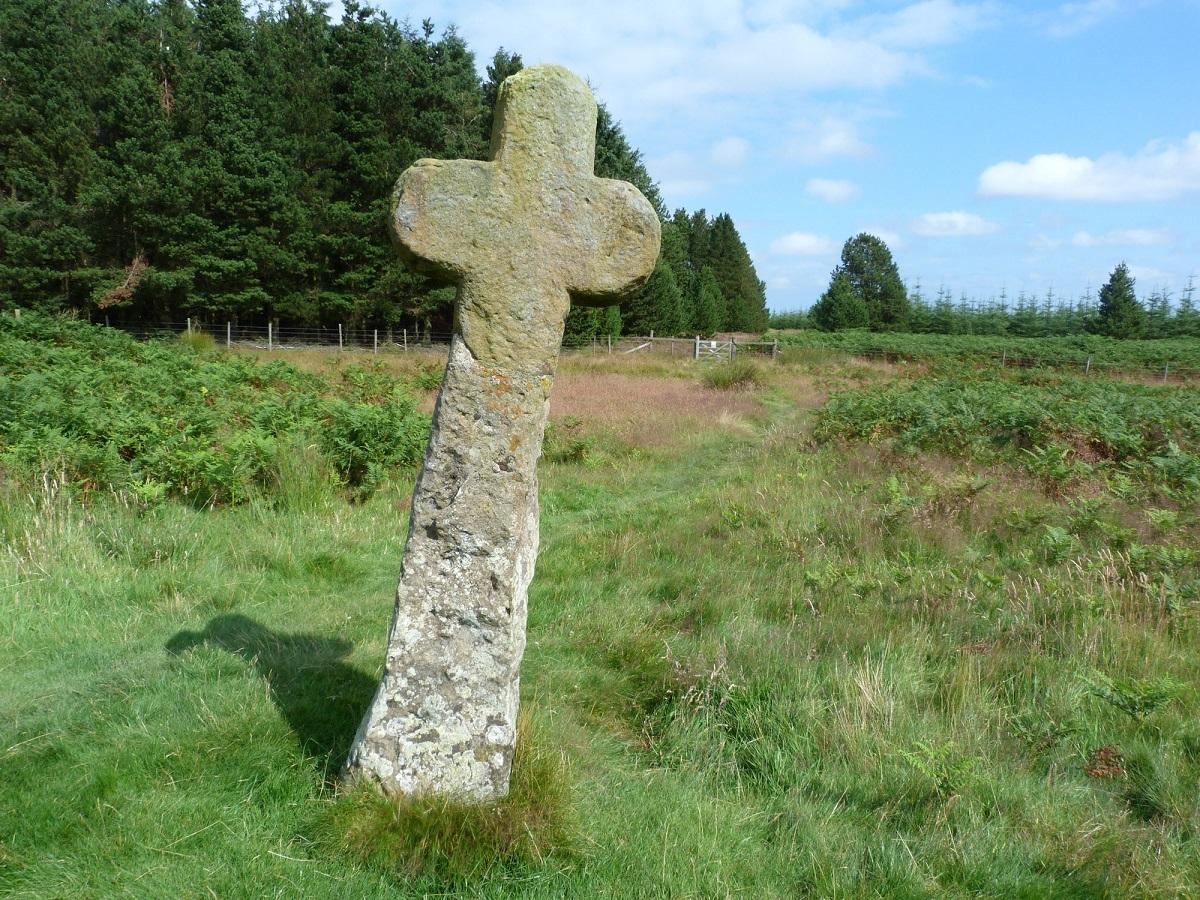
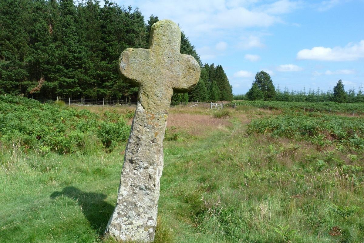
Before arriving at the boundary you will see Malo Cross. Malo Cross is one of a number of ancient stone crosses that remain as an obvious legacy of the Ancient Britons and their pagan ways. The crosses (roughly 2,000 remain across Britain but a number in the North York Moors) were built for a number of reasons, to commemorate a battle, mark a religious location, a place of penance or to mark a boundary. The latter is most likely in this case.
In addition Malo Cross is deemed a monolith cross ie: one placed directly in the ground, which is probably why it is now lob sided! If you do see some old coins scattered around it was left for poor wayfarers to buy food with, a tradition that has been replaced by today’s food banks.
From the cross turn left on a bridleway heading west and skirting up the steep hillside on to the slopes of Whinny Hill. The highest point of the hill is to the eastern end of the plateau (but not accessible), the remainder of the hill flat.
Where the path turns in to a track enjoy the views north and east in particular. RAF Fylingdales dominates the view but it is also possible to appreciate the views further afield across the wild moor. In the far distance I was able to pick out the distinctive shape of Roseberry Topping.
On meeting a wall turn south/left and continue along the hillside, a trig point clearly visible to the left. The path finally rejoins Old Wife’s Lane near the main road.
* Fact Box:
Distance: Roughly four miles
Height to Climb: 80m (260 feet).
Start: SE 852397. Park at the Hole of Horcum car park on the A169.
Difficulty: Easy. A short walk on good tracks with only one climb.
Refreshments: There may be a butty van at the car park but if not travel south to Lockton.
Be Prepared: The route description and sketch map only provide a guide to the walk. You must take out and be able to read a map (O/S Explorer OL27) and in cloudy/misty conditions a compass. You must also wear the correct clothing and footwear for the outdoors. Whilst every effort is made to provide accurate information, walkers head out at their own risk.
Please observe the Countryside Code and park sensibly.
* Jonathan Smith runs Where2walk, a walking company in the Yorkshire Dales. He has written his own book, the Dales 30, which details the highest mountains in the Dales. He also runs one-day navigation courses for beginners and intermediates.
Join his Learn a Skill, Climb a Hill weekends in the Dales. Visit where2walk.co.uk


Comments: Our rules
We want our comments to be a lively and valuable part of our community - a place where readers can debate and engage with the most important local issues. The ability to comment on our stories is a privilege, not a right, however, and that privilege may be withdrawn if it is abused or misused.
Please report any comments that break our rules.
Read the rules here